Being on the water has always been adventurous. And for all the reasons that we love boating the one task that has evolved more than any other in the past 25 years is navigation.
GPS coverage and accuracy combined with the processing power of today's mobile devices and chart plotters provide a level of precision and confidence heretofore unavailable.
Contributing editor Bob Sherer (aka Bob423) compiled a list of activities that we exercised when we plotted courses and skippered our boats at the turn of the 21st century and compared them to how we get around today. Do you remember when?
Then
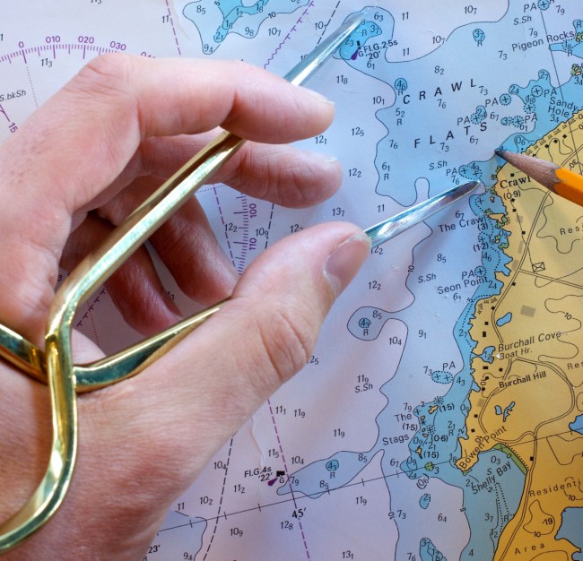
- You had a library of paper charts stowed on the boat.
- Your routes and waypoints were plotted on those charts.
- Parallel rulers were used with the chart's compass rose.
- You had a back-sighting compass in addition to an on the helm compass.
- You knew how to dead reckon because you never knew when fog would close in, or you could not determine your location from celestial observations.
- There was a stopwatch on board, and you probably had a good wristwatch.
- You could identify bell buoys (ATONs) and estimate direction and distance to and from them.
- You were aware of other sounds such as water lapping against shore or the sound of other boats, especially in fog or reduced visibility.
- You learned how to estimate distances to ATONs by their apparent size.
- You understood foghorn signals.
Advancements along the way
- We transferred waypoints from paper charts to our GPS devices to make routes.
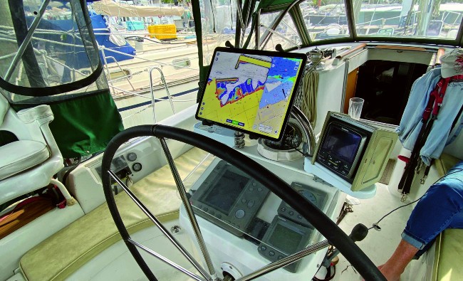
- Then chart plotters arrived and what a revolution. You could see your boat icon moving on the chart on the screen. Wow!
- Charts gradually were not spread out or referenced while underway.
Now
The proliferation of Apple and Android navigation apps with capabilities far beyond those early chart plotters.
- Chart plotter functions are now available in many mobile navigation apps.
- There is a standard format (.GPX) for sharing waypoints, routes, and tracks.
- We get multiple chart updates per year (versus the one or two updates we got with old style chart plotters.
- Weather information is integrated into many mobile navigation apps.
- Tides and currents are now superimposed on digital devices, which assist in estimating time to destinations and drift.
- Digital data from NOAA and USACE is now available to recreational boaters and mobile apps are amazingly robust, such as Aqua Map that displays USACE, ATON relocations and LNMs. SonarChart from Navionics maps bottom contours of the waterways.
- Community comments and reviews of anchorages, marinas and local conditions are available with a finger tap on many apps.
- AIS is inexpensive and accurate for most any vessel owner that wants to install it offering greatly improved visibility for all vessels.
Reflection
Are we safer now than in the past with these new technologies?
- What if they fail and we have no GPS, a mobile device dies, or a software update kills an app?
- Multiple backups are needed for devices and software, which complicates the equation.
- Do we still need to learn the navigation skills of yesteryear? Very few of us are going back to a sextant for coastal cruising. But basic navigation skills and situational awareness are still required. Know the ATONs (red, right, returning), port to port on-coming passing, and give way versus stand on vessel positions.
Boating should be fun and part of having fun is being safe. Modern tools provide accurate tracks, timely weather information, including weather radar via internet, electronic navigation charts (ENC) with regular data updates, USACE surveys displayed for navigation and so much more.
There is little nostalgia for the old tools of navigation. They worked in their time, but today's technologies are better and we're not going backwards. Where will we be in another 25 years?


- 4,000 Marinas
- Thousands of anchorages
- Updated Charts
- Mile-by-Mile Navigation
- Highlighted Alerts & Cautions
- Full-Color Aerial Photographs

The Waterway Guide App Makes it easy to leave reviews, use our explorer, and view waterway guide materials all on the go!


