
Look no further than Shelter Island, Fishers Island, Block Island, Martha's Vineyard, and Nantucket to find a sailor's wonderland of islands with deep water boating, freshening southwest breezes throughout the summer and fall, charming historic sea towns, sunrises and sunsets that will calm your soul and miles of beautiful unspoiled beaches preserved by those who respect nature around them. Each one of these five islands, off the coasts of New York, Rhode Island, and Massachusetts, offers something different but, at the same time, each offers that same magical destination reachable only by boat or ferry, and that alone draws us back time and time again. In her book, A Gift from the Sea, Anne Morrow Lindbergh wrote, "How wonderful are the islands! The past and future are cut off; only the present remains." This may be what draws us to them and why we look toward our next cruise to one or all of the beautiful islands of the Northeast waters.
Shelter Island
While on board our sailing vessel Mimi, we usually head first to Shelter Island, held between the arms of the South Fork and the North Fork of Long Island. Once through Plum Gut (a passage made smoother if timed with the tides), we head around Orient Point toward Greenport, where Dering Harbor on Shelter Island lies to port. Moorings and marinas can be found in this easy-to-navigate harbor, which offers a short walk to town where you can find bike rentals, restaurants and kayak rentals. Grab a bike and enjoy the fabulous trails and beaches as the island opens up to acres of land kept in a forever-wild state.
If you prefer a busier town or a wine tasting tour, take the Greenport car ferry from Dering Harbor. On the south side of the island, the beautiful Coeckles Harbor has marinas and anchorages and is nearby to the small ferry that goes over to Sag Harbor on the South Fork. Another harbor on Shelter Island is West Neck Harbor, scenic and well protected with a nice marina that offers transient dockage and a waterfront restaurant, Salt, where we often enjoy the catch of the day, watch the sunset and make plans for our morning departure to Block Island, a delightful trip out past Montauk and across Block Island Sound.
Block Island
The Nature Conservancy once designated Block Island, one of the original, "Last Great Places." Our family loves this wonderful, never-changing oasis that lies 14 miles south of Point Judith, Rhode Island and east of Montauk, New York. My sons with our family cruised here every summer, got married here and now bring their own children here. Boaters can choose between two harbors: Old Harbor on the east side of the island and the Great Salt Pond on the west side of the island, where the harbor offers all the attributes of a cruising mecca: easy access, plenty of water, good marinas with repair capabilities, great shelter, excellent beaches, restaurants and room to anchor. While heavy fog can sometimes be a nuisance in your passage to the island, a GPS and radar make the transit very doable, as long as you keep an eye out for the ferry traffic from the mainland.
For some reason, when you enter the Great Salt Pond Harbor, the sun is shining and the fog is gone. Opt for one of the 90-plus moorings usually available if you arrive early in the day. Green moorings are for boats under 40 feet and orange moorings for heavier boats. The Old Town launch, reachable on VHF Channel 68, services the moorings and anchorage. The harbormaster monitors VHF Channel 12 and can answer any questions if no moorings are available. Transient dockage with many amenities for slip users is available at one of the four marinas in this harbor. Fuel is available at Champlain's Resort and Marina or Payne's Dock. Call the pump out boat on VHF channel 68, or if you need fresh water, the water boat can also be reached on 68. Anchoring is also an option; however, the dedicated anchorage is often crowded. Whatever your preference, you will soon be caught up in the magic of Block Island that includes the early morning sound of Aldo singing "Andiamo" throughout the mooring area announcing the delivery of fresh baked goods to your boat.
Block Island is not a fancy place with high-end shops and five-star restaurants; it is a comfortable home. We return again and again to find unchanged, beautiful beaches; miles and miles of bike riding; the same wonderful breakfast on the front porch of the The National Hotel in Old Harbor or the Narragansett Inn in the Salt Pond; the afternoon music and lobster dinners on the beach at Ballard's Beach Resort; swordfish at Dead Eye Dicks; a visit to the ever-expanding zoo and dinner at Hotel Manisses; and always a great happy hour at The Spring House Hotel in Old Harbor or at The Oar in the Salt Pond. The Oar has been a Block favorite for many years, where sailors hang their own personalized oars to commemorate their visit. We have several there now as boats change and weddings happen. Another reason to get back to Block as often as we can!

Martha's Vineyard
After a few days on Block, if the weather looks good, you may opt for the short passage over to Martha's Vineyard (MVY), where the only decision to be made is which harbor should we go to on this trip? If you are on a sailboat, enjoy the Vineyard sleigh ride from the prevailing southwest winds as you head up Vineyard Sound. From the west, your first sighting of MVY will be the multicolored, breathtaking hills of Gay Head.
There are four distinctly different harbors on MVY: Menemsha, Vineyard Haven, Oak Bluffs, and Edgartown. Each harbor is unique and all offer beauty, elegance and class. As on-islanders say, leave your shoes behind when you step ashore at the Vineyard. Whether you have two days or two weeks, you can grab a bike at any of the bike rental shops and set off on the 16.4-mile-long Vineyard Haven-Edgartown-Oak Bluffs loop from any one of the three harbors to experience an extraordinary Down Island adventure on Martha's Vineyard. Public beaches are numerous: three in Oak Bluffs, six in Edgartown and two in Vineyard Haven.
Menemsha is a fishing port that is working at staying unspoiled, where you can hike along vacant dunes and watch the long liners unload and socialize with local artists. Menemsha basin is home to lobster boats, trawlers, sport anglers and charter and party boats. Picturesque shanties used by fishermen line the crowded harbor head, as do restaurants and fish markets; what you won't find is beer or wine, as Menemsha—like many towns on MVY—is dry, so bring your own if you wish. Transient dockage is available in Menemsha Harbor.
Vineyard Haven resembles an old New England village and is the island's chief port. A very busy commercial and recreational harbor, Vineyard Haven has many moorings, marinas, ferry traffic from the mainland, tall ships, and many provisioning opportunities, shopping and dining, all within a short walk up the hill from the harbor. If you plan to stay a while, bike rentals and car rentals are available, and the famous beaches of MVY are a short distance out of town. The Chamber of Commerce is located a short distance from the harbor and worth the trip to pick up maps of MVY, information about current events in all harbors and some great information about the historic towns on the island.
Oak Bluffs, the resort harbor of MVY, is small, crowded and hectic, but a festive scene. The harbor is ringed with a boardwalk atmosphere that continues along the beach for a great distance past the ferry terminal. The town became a center of the 19th century Methodist movement and the "Camp Meeting Grounds" with more than 300 multicolored, elaborately trimmed carpenters' Gothic cottages remain today. A walk through this area is not to be missed, as is a walk to East Chop Light, one of the many often-photographed points on MVY. The Flying Horses, America's oldest operating brass-ring carousel, dating from 1876, operates just half a block east of the town harbor.
Edgartown retains the ambiance of a prosperous colonial whaling center and is a town for walking and breathing deeply the air of another time, complete with boutiques, restaurants and pubs, most of which can be found on Main Street and Winter Street. Beautiful yachts of the wealthy can be seen coming and going on a daily basis. The town has moorings serviced by launch, but advance reservations are a good idea during the height of summer. A slip at the marinas here can be reserved ahead of time.
The beaches around Edgartown are known for their beautiful white sand. A stroll down one of the narrow brick streets lined with majestic old homes will give you an instant feel for Edgartown's rare combination of charm, maritime history and beauty. Most of the elegant captains' homes can be found on North Water Street. Walking tours are a nice way to learn the history of this famous whaling community. A walk along the beach to Eel Pond towards the Edgartown Lighthouse is not to be missed. The Chappy Ferry moves cars across a few at a time to the island of Chappaquiddick, 12.8 miles of sandy beach, wildlife preservation and the Mytoi Garden, open year-round and free to the public.

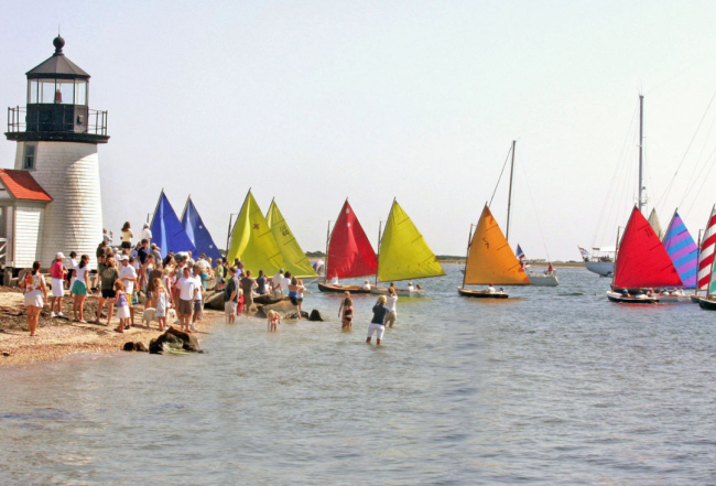
Nantucket
Nantucket, 27 miles offshore from Cape Cod, is 14 miles long and 3.5 miles wide. When you first step ashore, you will be overwhelmed by the feeling that you are stepping back in history when whaling ships filled the port, and sea captains walked the gas-lit cobblestone streets. The entire island is a historic Landmark with 50 designated marks of history. Do not miss an opportunity to visit this island out of time.
Nantucket offers much for a cruising family, including a maritime history lesson. The famous whaling museum is a great place to understand Nantucket's importance in shipbuilding that began the whaling industry in this country. The homes of sea captains abound throughout the town and walking about on the cobblestone streets easily brings you back to the days when excitement of returning whalers brought out the entire town. Maureen and Bob Kennedy, who live aboard their Island Packet, Emerald Isle, recently visited Nantucket and wrote, "We love Nantucket with its old captain's homes and lovely B&Bs, cobblestone streets, guest cottages on the dock, an old bookstore, distinctive boutiques and exciting people watching. All of this within walking distance of the very active harbor; a destination not to be missed."
Transient dockage is available in the harbor where slips accommodate boats from 30 feet to 200 feet. The concierge, who is located on the fuel dock, will arrange restaurant reservations, sightseeing trips, car rentals, and much more. Making reservations are necessary before March if you plan to stay at this popular, end-destination. Currently, there are 125 transient moorings secured by heavy tackle that can be reserved in advance of your planned trip. For an additional fee, Harbor Launch (VHF Channel 68) will provide transportation to moorings or anchorage. The pump out boat, Head Hunter, can be reached on VHF Channel 09.
The island is kidney shaped and has pristine beaches on all three sides. Definitely rent a bike to take full advantage of this beautiful island and do take an exhilarating early morning walk out to Brant Point Lighthouse. Children's Beach on the harbor sports a playground and park. The beach is an easy walk from town and a great spot for children. You can find a good map for all Nantucket beaches at www.nantucketchamber.org or by visiting the Nantucket Chamber of Commerce when you arrive at the island.
Nantucket is not just for beaching and walking, it is also a destination complete with shopping and numerous restaurants for every taste from a casual crab shack to five-star dining. As Herman Melville wrote in Moby Dick, "Nantucket! Take out your map and look at it. See what a real corner of the world it occupies: how it stands there, away off shore…"
Fishers Island
When time comes to leave Nantucket, head west toward Cape Cod or over to MVY and through Vineyard Sound toward Long Island Sound. Before you head through the Race into the Sound, visit one last island on your way home by taking the Watch Hill Channel on the west coast of Fishers Island.
Nine miles long and 1 mile wide, Fishers Island lies 2 miles off the southern coast of Connecticut. The island is a stretch of sand that can only be reached by ferry from New London, Connecticut, and much of the island is private. If you are looking for an exciting destination with entertainment, this island is not the place to be a tourist; however, it is the place to enjoy a quiet anchorage for the night and that might be just the thing as you wind your way home.
Beaches on the west end of the island extend for a couple of miles to the western tip known as Race Point and are famous for fishing tidal rips and sunset by its picturesque lighthouse. There are no traffic lights on Fishers Island, and services are limited to a very small village with a supermarket, the Pequot Inn, which has the only bar and restaurant with limited fare, a small museum and a café. A marina is centrally located in West Harbor and has transient dockage with launch service. The marina is a good place to begin your exploration of this quiet picturesque island. Everything is within easy walking distance.
As you leave this quiet island, look toward Gull Island, just off of West Harbor where you will see the largest nesting population of common and roseate terns on the east coast, a nice memory to carry home with you as you plan your next cruise island hopping in the northeast.
Carol Pierini is a lifelong, northeast sailor who grew up on Barnegat Bay, New Jersey. She is a professional healthcare writer and copyeditor who has leaned more and more into maritime writing, where her love of the sea and harbors of the northeast constantly open up new cruising grounds and more exciting writing material.


- 4,000 Marinas
- Thousands of anchorages
- Updated Charts
- Mile-by-Mile Navigation
- Highlighted Alerts & Cautions
- Full-Color Aerial Photographs

The Waterway Guide App Makes it easy to leave reviews, use our explorer, and view waterway guide materials all on the go!


