By Michael O'Reilly

Bang! Splash! Crash! It's never good to be awakened by hitting the ceiling of your cabin berth…
I quickly struggled out of bed and made my way to the companionway. My stalwart partner and spouse was struggling with the helm as yet another frothy wave crashed over us.
"Everything OK?" I somewhat foolishly asked/yelled. "Yes! Perfectly fine! Go back to bed," hollered Ann through gritted teeth. Needless to say, all was not fine.
We had just sailed 40 hours across the Gulf of St. Lawrence and were within sight of Newfoundland's western shore. But a major front that was supposed to be 12 hours away had sped up and caught us, and we were in for a very rough ride.
It felt like Newfoundland was testing us. Perhaps it wanted to see if we were worthy to make landfall on this remote island province. It took another 6 hours to travel the remaining 15 miles, but we eventually made it. And so ended our journey down one of the world's great waterways–the St. Lawrence River.
From its headwaters at the eastern edge of Lake Ontario, down to the expanse of the Gulf of St. Lawrence and the Atlantic Ocean, the river runs a length of nearly 650 nautical miles (approximately 1,200 km or 750 statute miles). It passes by some of North America's most historic communities and busiest waterways. There are tides that can reach 20 feet in places, as well as very fast and shifting tidal currents, all of which demand careful planning and constant awareness.

It is not a journey to be taken lightly, or quickly. This is why relatively few boaters choose this route when travelling to (or from) the Atlantic. But for those with the time and the desire to travel a little off the beaten path, the St. Lawrence loudly beckons.
We left Lake Ontario in early summer in 2017, riding a higher-than-normal downstream current that added 1 to 3 knots to our typical slow cruising speed. We quickly passed through the Thousand Islands area, sailing by the many smaller historic communities of Ontario and New York State that straddle the slowly widening river.
The commercial traffic in this section of the river can be challenging, especially in the approaches to the locks. There are seven large locks between Lake Ontario and Montréal, which help create the St. Lawrence Seaway, one of the busiest shipping routes in the world. These locks lower/raise a vessel approximately 240 feet from the height of Lake Ontario to sea level.
Five of the locks are located in Canada, while two are in the U.S. The Canadian locks provide long lines tied to dock cleats, while the two American locks use a floating bollard system. The lock staff are very helpful and accommodating. If you purchase your lock tickets ahead of time over the Internet, you'll save money ($5 off per lock) and avoid the hassle of buying lock tickets on site.
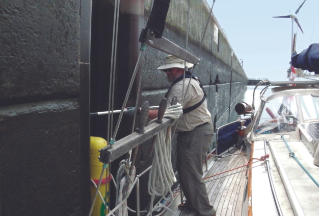
Montréal is the first major city along this route. It is well worth a stop but beware of the ferocious currents as you exit the last lock. Boats with small engines (like ours) will find the approaches challenging. As it was, we bypassed the city in favor of a slightly more secluded anchorage not far downstream.
From here, the river continues to widen and begins to take on a slightly wilder, more remote feeling. We sailed past the small Québec city of Sorel-Tracy, which sits at the confluence of the St. Lawrence and Richelieu Rivers and is detailed in the Triangle Loop section of Waterway Guide's Great Lakes edition.
A short hop from Sorel took us to the city of Trois-Rivières and the beginning of tides and tidal currents. As Great Lakes sailors, we had little experience dealing with these things called tides. So we anchored up a branch of the Saint-Maurice River (the three branches are the "trois" part of the city's name) and took a few days to re-learn how to read tide tables and to plan our next steps.
This section of the river is dominated by large tides of up to 20 feet and the related tidal currents that can run to nearly 10 knots in places. We quickly learned there was no point fighting Mother Nature with our sails or little auxiliary engine. We had to time our hops to ride the wave down on the ebb tide, and then make sure we could stop once it turned back towards us in the flood tide.
Québec City is one of those iconic places to visit along this route. Unfortunately, our arrival coincided with a festival of tall ships, meaning there was no dock to be had. We sailed past, taking in the incredible sights of this ancient city from the water and enjoying the nearly 40 tall ships docked all around.
As the river passes Québec, it begins to widen dramatically. By the time you reach the Saguenay River, it stretches over 12 nautical miles across. From here, most boaters choose to follow one side or the other. We chose to travel the north shore as our final destination was Newfoundland. Those heading to the Maritimes or further south will want to follow the south shore.
After a side trip exploring parts of the Saguenay Ffjord, which is famous for incredible vistas and beluga whales, we continued downstream to the port of Baie-Comeau and then Sept-Îles. From there we sailed overnight under a full display of the northern lights, stopping in Mingan National Park north of Anticosti Island. Mingan features shoreline monoliths reminiscent of the Bay of Fundy, plus a puffin colony and plenty of whales, dolphins, seals and other wildlife.
From Mingan we pointed our bow southeast and spent the next 46 hours sailing across the Gulf of St. Lawrence towards Corner Brook, NL. As mentioned at the start, the first 40 hours were glorious…but we made it.

Explore more options on the Great Lakes, here.
Purchase a Great Lakes Vol. 1 Print Guide or Subscription
Michael OReilly has been messing around with boats in remote areas of Canada for most of his life. Progressing from canoes and kayaks, he now spends his days living and cruising the Great Lakes, the St. Lawrence River and Newfoundland. While most of his articles have been in the sciences, he's now spending more time writing about the cruising life and the places he visits.


- 4,000 Marinas
- Thousands of anchorages
- Updated Charts
- Mile-by-Mile Navigation
- Highlighted Alerts & Cautions
- Full-Color Aerial Photographs

The Waterway Guide App Makes it easy to leave reviews, use our explorer, and view waterway guide materials all on the go!


