Nantucket Sound is an exciting and tempestuous body of water due to its well-marked shoals and it is a fabulous destination that can be traveled as though it's a very, very large bay. A circular voyage through its ports and anchorages begins with the natural beauty of the Elizabeth Islands, continues along Cape Cod's south shore harbors with plenty of marinas and turns for Nantucket at Hyannis Port, the last of the deep-draft harbors on the southern coast. Heading farther east is for shoal-draft boats only.
The prevailing southwesterlies give a close reach from Hyannis Port to the fabulous island of Nantucket and then a beam reach back northwest to Martha's Vineyard. These islands are a favored cruising grounds for thousands of recreational boaters. The best-known harbors grow ever more congested each season, while lesser-known ports are continually being "discovered" by those who seek refuge from the crowds. The discovery of hidden coves and harbors is one of the many joys of cruising these waters.
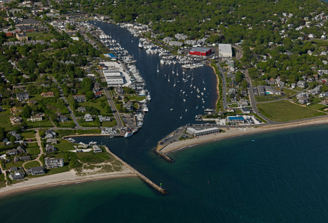
Falmouth
Falmouth is not only a good base for cruising the islands, it also has one of Cape Cod's best harbors with at least 8-foot MLW depths and every conceivable amenity. It is thoroughly protected and easy to enter. At the head of the harbor on the eastern side, the Island Queen passenger ferry will take you to Oak Bluffs on Martha's Vineyard. Band concerts in Falmouth are on the western side of the marine park and provide entertainment on Thursday evenings during the summer.
In town, the seasonal bustle of a seaside resort village awaits you. Houses built by ship owners and sea captains in the 18th and 19th centuries surround the traditional village green. Accommodations and dining possibilities are almost unlimited.
NAVIGATION: Use NOAA Chart 13229.
Flashing red bell buoy "16" about 0.50 mile offshore marks the approach to the breakwater entrance. The entrance is straightforward, although narrow with 6-foot MLW depths that are relatively consistent in the channel and throughout the dredged harbor. Past the entrance, the harbor broadens slightly and both banks are lined with marine facilities and amenities. This is a No-Discharge Zone and a pump-out station is located at the town dock. There is no room for anchoring here.
Dockage/Moorings:
Marine facilities line the Falmouth Inner Harbor with slips and moorings. Falmouth Marine & Yachting Center offers 15 slips and 15 moorings and offers maintenance, repairs, hauling and storage. Falmouth Town Marina has berths perpendicular to the seawall and space for transients to 200 feet. Use the [online form] (https://www.falmouthma.gov/264/Marina) to request a slip reservation.
Pier 37 is a restaurant that may have space for you (to 32 feet) if you dine with them. The Flying Bridge Restaurant (508-548-2700) has an easy-access fuel dock (at the Mobil sign) and several small finger piers for restaurant patrons.
MacDougalls' Cape Cod Marine Service on the western shore of the harbor has extensive marine amenities. They offer both moorings and slips (to 120 feet) and have a large on-site chandlery and retail supply store as well as specialty shops for installations, custom fabrications, sailmaking and canvas repairs. They rebuild and repower gas and diesel engines and have the largest paint booth facility on Cape Cod.
Although the town of Falmouth is located about 1 mile away, most of the essentials for provisioning and reviving water-weary crews are close to the marinas. A market, West Marine and liquor store are all on the west side of Scranton Ave. across from the Falmouth Town Marina harbormaster's office. A self-service laundry is a 5-minute walk north. Farther along at the end of Scranton Ave. and to the right, a fair-sized mall boasts chain stores and fast-food restaurants.
For more information on cruising the Nantucket Sound and its surrounding areas:
Purchase a Print Waterway Guide Northern 2023 Edition.
Purchase a Waterway Guide Northern 2023 Edition Subscription.


- 4,000 Marinas
- Thousands of anchorages
- Updated Charts
- Mile-by-Mile Navigation
- Highlighted Alerts & Cautions
- Full-Color Aerial Photographs

The Waterway Guide App Makes it easy to leave reviews, use our explorer, and view waterway guide materials all on the go!


