During Captain John Smith's three years in Virginia he traveled nearly 3,000 miles, claiming: "Heaven and Earth never agreed better to frame a place for Man's habitation." As Capt. Smith traveled on the Bay and its rivers, he recorded and mapped what he saw.
Now you can more easily explore the Chesapeake Bay as Captain John Smith did it–by boat. A Boater's Guide to the Captain John Smith Chesapeake National Historic Trail by John Page Williams allows you to paddle, sail or motor on a parallel journey along the waterways traveled by Smith. This guide is a joint project of the National Park Service, the Chesapeake Conservancy and the Chesapeake Bay Foundation. You can download the guide, here. The trail combines history, the natural environment, and outdoor recreation and covers the following areas in the Chesapeake Bay:
- James River
- Chickahominy River
- York River System
- Rappahannock River
- Potomac River
- Patuxent River
- Main Stem of the Bay
- Patapsco River
- Head of the Bay
- Nanticoke River
- Lower Eastern Shore
Typical trail markers obviously wouldn't work on the Bay, so NOAA placed a series of buoys to mark the watery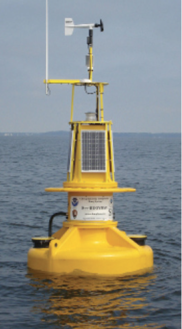 Captain John Smith Chesapeake National Historic Trail. These buoys transmit observational data for trail users, collect water-quality and other scientific measurements for monitoring the health of the Bay, and communicate current and historical information for the public and educators. To date, 10 buoys are stationed in the Chesapeake Bay along the trail:
- Susquehanna River near Havre de Grace, MD
- Mouth of the Patapsco River near Baltimore, MD
- Mouth of the Severn River near Annapolis, MD
- Upper Potomac River just south of Washington, DC
- Gooses Reef near mouth of Eastern Shore's Little Choptank River
- Mouth of the Potomac River
- Rappahannock River near Stingray Point, VA
- James River near Jamestown, VA
- Mouth of York River
- Mouth of Chesapeake Bay near Virginia's First Landing State Park
Recreational and commercial boaters rely on the buoys for real-time data on wind, weather, wave height and currents. Data from the buoys help boaters make safe choices before venturing into the open waters of the Bay.
You can download the NOAA Smart Buoy App from the Apple Store or Google Play.
For more information on the Captain John Smith Chesapeake National Historic Trail and the corresponding buoys visit https://www.nps.gov/cajo/planyourvisit/maps.htm


- 4,000 Marinas
- Thousands of anchorages
- Updated Charts
- Mile-by-Mile Navigation
- Highlighted Alerts & Cautions
- Full-Color Aerial Photographs

The Waterway Guide App Makes it easy to leave reviews, use our explorer, and view waterway guide materials all on the go!


