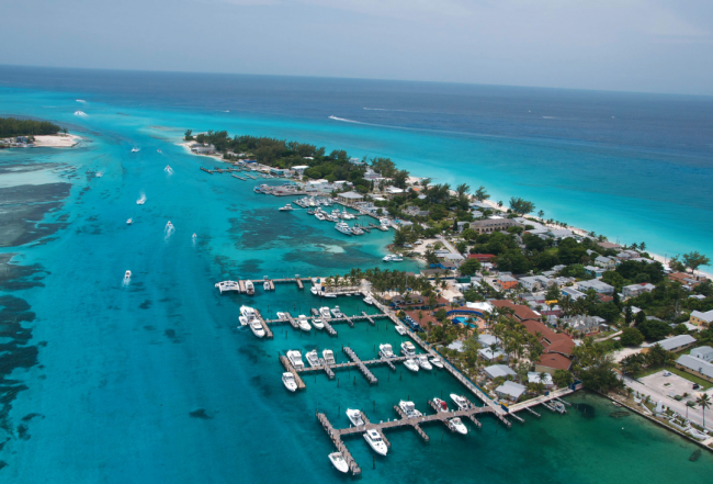
For many coming from the southern parts of Florida, Bimini is the main point of entry into The Islands of The Bahamas. The islands are a mere 50 nm east of the U.S. mainland and–even contending with the Gulf Stream's northerly push–most boats with any speed can comfortably leave for these islands at daybreak and reach them before sunset. The main settlement of Alice Town is located on North Bimini, which is divided by a narrow channel from the quieter residential areas on South Bimini. It's a popular port of entry, but it's a destination in its own right with a charming community of locals and a large resort complex.
The Bimini Islands location is convenient enough that many begin their cruise here or come to the Bimini Islands for a mini-getaway from Florida. Convenience aside, the Bimini Islands are an all-time favorite cruising destination for many other reasons:
-
Some of the best sport fishing found anywhere in the islands. The deep waters of the Gulf Stream to the west make Bimini a prime deep-sea fishing destination. There is superb snorkeling on the reefs along the shores of the islands and lots of big wildlife swims through. The eastern side of the islands abuts the Grand Bahama Bank and features miles and miles of shifting shallow sandbars, making this area is the perfect playground for flats fishermen to try their fly fishing skills.
-
Great diving and snorkeling with sites that eclipse Florida's best.
-
Distinct vibe. There is no mistaking that you are not in the U.S. as you stroll along the one-car-width King's Hwy.
Whether you're seeking Bimini's rustic beauty or its lively shops and eateries, Bimini is a great place to visit or to spend a few nights before setting off across the Great Bahama Bank or waiting out a blow to return to the east coast.
Navigation Notes
The contrasts in navigational challenges here are stunning. While most cruisers realize that the passage from Florida across the Gulf Stream requires some planning and careful weather consideration, so does the passage across the Great Bahama Bank and its neighboring deep channels. The Bank is wide open with no protection, and the shallow waters can kick up a mean steep chop when the wind picks up. Likewise, the deepwater passage to Nassau is not to be taken lightly, especially if you are looking to make passage through unfamiliar cuts at each end.
For cruisers who are looking to make the most of suitable weather for eastbound travel, it is not necessary to stop in Bimini at all. If you opt to bypass the Bimini Islands, there are three main routes that pass Bimini and continue onto the Banks (described in detail in Chapter 8: The Great Bahama Bank). Most cruisers choose to enter the banks north of North Rock or through the Gun Cay Cut. From there, continue on to the Northwest Channel, heading straight across the Great Bahama Bank. Although many slower vessels do anchor on the Great Bahama Bank, please keep in mind that there are more and more island freighters traveling at night from Florida to the Berry Islands and Nassau. If you anchor here, plan to have an anchor light and a lookout.
When transiting the west side of North Bimini be aware of the large cruise ship dock that extends from shore directly off Bimini Bay Marina to N 25° 45.054'/ W 079° 17.270'. On charts, but not in reality, the entrance channel into Alice Town's harbor is clearly marked with red and green flashing buoys. From the Bimini waypoint the channel lines up almost directly with the channel through the jetties into the Bimini Cove Resort & Marina on South Bimini. The buoys marking the channel and the channel itself are frequently moved or off station. The channel with the deepest water is just off the entrance to the resort. Conditions change continually here.
You will need to approach carefully and if you have a deep-draft vessel, make sure to contact your Bimini dockmaster for up-to-date advice. There is a shoaling sand bar extending south from the tip of North Bimini Island. Once over the tip of the bar and near the South Bimini beach, keep that sandbar to port and turn north to parallel the shoreline of South Bimini into the Alice Town harbor entrance. There are usually markers along this channel but visual piloting is more reliable. Use great caution in this area and during these approaches if wind or seas are running out of the southwest through west.

Older charts show another more southerly approach channel hugging the long beach along the western shore of South Bimini. For boats with drafts of less than 1.5 meters/5 feet, this may still be a viable passage into Alice Town or an alternate route for Bimini Cove Resort & Marina. There is a range on this approach, and this is the recommended approach in low light or rough conditions. Turn north after you are safely past the sandbar keeping the rocks and shallows to port. You will be close to the beach but in deep water.
All vessels must exercise caution entering Bimini as ocean swells in the cuts can cause you to hit bottom. Read the water carefully. At any state of tide go cautiously on your final run in, watch your depth and be prepared to abort if necessary. With all the changes and dredging that have taken place here, contact one of the local marinas to get the latest information.
If the wind is from the west and any kind of significant sea is running, neither approach is usable. Don't attempt it! It is better to head offshore and take your lumps to continue to Gun Cay or North Cat Cay.
Other suggestions:
Conditions: Beware trying to enter Alice Town in southwest through northwest winds, particularly if the sea state is building. In moderate conditions you should be fine, but you are exposed broadside running along the beach on the west shore of South Bimini. You are very close to the beach as you do the final leg. Do not attempt it in unfavorable weather!
Approach Markers: The range markers for the southern channel off South Bimini and the approach markers can be hard to locate. If you don't spot them, run slowly up and down parallel to the beach. Stay in deep water until you have them fixed or call a local dockmaster for advice.
Chart Accuracy: The GPS may place you on the sand by Pigeon Cay by the time you are at the slip. Remember, the GPS may not be perfectly accurate and the chart position in the GPS may not be accurate either. As always, treat every GPS waypoint with caution and the charts with reservation. It is your eyes that are the most reliable; visual piloting applies for all inshore or shallow water navigation while in The Bahamas. Good light and polarized sunglasses are essential.
For more information on cruising in the Bahamas, purchase a Print Waterway Guide Bahamas Edition or a Bahamas Subscription.


- 4,000 Marinas
- Thousands of anchorages
- Updated Charts
- Mile-by-Mile Navigation
- Highlighted Alerts & Cautions
- Full-Color Aerial Photographs

The Waterway Guide App Makes it easy to leave reviews, use our explorer, and view waterway guide materials all on the go!


