From Louisiana to Mexico, the Texas coast covers over 400 miles. To the south, 113-mile-long Padre Island is the longest barrier island in the world. The Texas coast is a series of these type of barrier islands and narrow sandbars that protect the coastal prairies and plains, lagoons, bays and the GIWW. The many large rivers that run through Texas flow to the Gulf of Mexico. Because of their currents, silt from these rivers makes the waters murky along much of the upper and middle coast. Most communities along the coast are small and cruisers will find that these communities are quaint and the people are friendly.
After the relatively short Alabama and Mississippi Gulf Coast segments and the Creole-flavored Louisiana GIWW run, the long Texas coastline slowly transforms its scenery gradually shifting to the tropical. Passes between the extended low barrier islands are scattered about one day's run apart. The vast majority of the coast is made up of marsh islands that are sometimes little more than sandbars or shoals. Big, choppy bays run almost the entire length of the Texas coast. The bays are steeped in history and based on the waterborne commerce that created Texas Gulf communities.
The upper half of the Texas coastline from Sabine to Corpus Christi has frequent and well-placed marinas and anchorages. This top half of the Texas GIWW is well traveled by barge and tug traffic, especially from Sabine to Freeport where numerous petrochemical refineries are located.
Navigation Notes
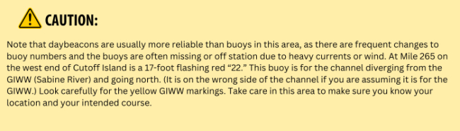
On the north side of the GIWW, the Texas border begins at the Sabine River just 2 miles downstream from Orange; however, on the south side of the GIWW, Louisiana continues until Mile 272 WHL. To further complicate matters, Pavell Island is in Texas, while Cutoff Island (farther west) is in Louisiana. The charted course will not follow the circuitous nature of the state line, but that line is indicative of this complex and sometime confusing stretch of water. Chart your course carefully and remain aware of your location with regard to the islands, bayous, cuts, channels and rivers that intersect with the GIWW.
Note that the buoy and daybeacon colors are reversed here since ship channels are the preferred channel and follow the red-right-returning protocol.
The GIWW runs along the northern edge of Sabine Lake from Mile 272.5 WHL to the mouth of the Neches River at Mile 277 WHL. The channel is 200 feet wide and 30 feet deep to the junction where the Sabine River meets the Neches River. When you pass green "67" and red "68," Humble Island will be on the north side of the GIWW and Stewts Island will be to the south. Immediately past the two islands the Neches River branches to starboard in a northerly direction leading to the City of Beaumont. The GIWW continues to port (or south) in the Sabine-Neches Canal. Avoid the temptation to turn north into the Neches River if your intention is to stay on the GIWW.
For more information on cruising the Gulf Coast, purchase a Print Waterway Guide Gulf Coast Edition or a Gulf Coast Subscription.


- 4,000 Marinas
- Thousands of anchorages
- Updated Charts
- Mile-by-Mile Navigation
- Highlighted Alerts & Cautions
- Full-Color Aerial Photographs

The Waterway Guide App Makes it easy to leave reviews, use our explorer, and view waterway guide materials all on the go!


