Think of the Caicos Bank as a 60-nm wide, circular, reef-fringed atoll. Water depths on the Bank run from around 6 meters/20 feet to 0 MLW. Proven transit routes carry about 2.4 meters/8 feet. Much of the Bank remains unsurveyed. Whatever the skill level, the prudent sailor will ensure that visual navigation is employed when transiting Turks and Caicos. This means daylight travel only and in sunlight and good weather facilitating bottom reading. The navigation aids are not always reliable and shifting sands and submerged rocks and reefs are just some of the hazards. Tide highs and lows are close to Nassau high and low tides. For this reason transiting boats usually anchor one night out on the Bank.
The Turks Bank runs from northeast to southwest for roughly 36 nm. Navigable in part, it is much like the Caicos Bank. Similar to The Bahamas, both have claimed many ships as victims since Juan Ponce de León discovered the islands in 1512. As always, safety means keep an eye on the weather, don't attempt a night passage and use the sun to your advantage. We don't recommend running on autopilot while crossing.
The ocean waters around Turks and Caicos are deep, plunging to 3,600 meters/12,000 feet between the Dominican Republic and the islands and even more in the nearby open Atlantic. Three banks to the southeast–the Mouchoir, Silver and Navidad Banks–shoal to 18 meters/60 feet or less and have coral that is awash at mean low water.
These Banks are the winter breeding ground for the Atlantic humpback whale population. The adults and calves migrate from here every year to the New England coast for the summer. At 22 miles wide and 2,100 meters/7,000 feet deep, the Turks Passage is part of their long-established ocean highway.
Turks and Caicos claim to fame is the underwater world. The colors, clarity and warmth of the ocean and Bank waters are unbelievable. The reefs are pristine. The diving is world-class, from shallow reef dives to breathtaking wall dives. The fishing is also excellent. Turn shoreward and Turks and Caicos beaches are made up of gently shoaling water and soft white sand.
Landfall & Departure Points
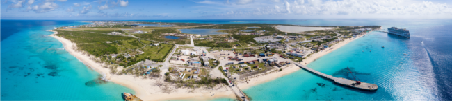
The islands' geographic location midway between Florida and the Caribbean makes them very important to the voyaging mariner. Three of the inhabited islands–Providenciales (commonly called "Provo"), South Caicos and Grand Turk–currently offer shoreside facilities and shelter to the cruising visitor. Provo offers the most marina options and is the spot to which you are most likely to visit.
Provo provides just about everything you'd need including a good shipyard. South Caicos can serve as short-term shelter, while Grand Turk, pleasant though it is, lacks any significant marina facilities. Grand Turk Island's North Creek could be a hurricane hole for very shallow draft vessels but don't consider it if you can't get there before the onset of severe weather.
There are a handful of other cays–one sparsely populated and the others uninhabited–that can offer you shelter in reasonably good weather and a chance to get some sleep before you continue on your passage. They also offer the chance to swim, snorkel, dive and beachcomb. French, Fish or Ambergris Cays on the rim of the Caicos Bank are the most obvious choices. Salt Cay and Big Sand Cay may be your best bets on the Turks Bank. The other islands and cays are best left for very shoal-draft vessels to explore.
Some cruising sailors may think that Turks and Caicos are just too far and too remote to be attractive as a destination but we encourage you to think again. If you want to push the envelope a little bit, to voyage out and find new places, you might well decide to visit Turks and Caicos.
Pilots are available for first-time travelers looking for assistance into marinas and through channels. Check with locals or ask at the marinas.
Climate & Weather
Local weather can be acquired from the Cruiser's Net, VHF Channel 18 from South Side Marina at 7:30 a.m. daily. The climate is tropical with temperatures averaging 24 to 27°C/75 to 80°F in winter (November to April) and 29 to 32°C/85 to 90°F in summer (May to October). The prevailing winds are the Trades–easterly to southeasterly–but these winds, which do much to moderate temperature and humidity, rarely bring rain. The annual average rainfall is only around 29 inches.
During the winter the islands are affected by northers. Cold fronts from the northwest are heralded by a period of calm, invariably followed by the standard wind switch to the southwest then to the northwest as the front moves through. It brings dark skies and disturbed seas, making reef cuts temporarily impassable and anchorages unpleasant and perhaps–depending on their location–untenable. A day or longer may elapse before the weather returns to normal.
As with The Bahamas, the hurricane season runs from June through November.
Tides
Tidal information is based on Hawks Nest anchorage (N 21º 26.000'/W 071º 07.000'), which is the sea area immediately to the southeast of Grand Turk Island. The mean range is 0.9 meters/2.9 inches. The tide set on the Caicos Bank is about 1 knot-plus, running northeast on flood and southwest on the ebb. The Turks Island Passage has a strong northerly set.
VHF Radio
International rules generally apply in the Turks and Caicos and VHF Channel 16 is the distress and primary calling frequency. Otherwise, channel usage is:
- Commercial Vessels–VHF Channel 68
- Working Frequencies–VHF Channels 09, 12, 14, 65, 69, 74
- Taxis–VHF Channel 06
- Public Bus–VHF Channel 70
Marine Police
The Turks and Caicos Islands do not have a Coast Guard so the police tend to be the lead agency for anything to do with the enforcement of their border. Their biggest concern is the interdiction of drugs, firearms and people from the south, coming through Turks and Caicos and then trying to go onward to The Bahamas or U.S.
As with the U.S. Coast Guard and the Royal Bahamas Defense Force, the Marine Police of the Turks and Caicos have the right to board and inspect any vessel in their territorial waters.
About The Islands
There are two distinct groups of islands that make up the country that is the Turks and Caicos Islands (TCI). The Caicos, most of which form a crescent around the northern edge of the Caicos Bank, make up the majority of the landmass. The Turks including Grand Turk, Salt Cay and many smaller cays are to the east are separated from the Caicos Bank by the deepwater of the Turks Island Passage. The Turks and Caicos combined comprise a total of 40 islands sprinkled over 193 square miles, only 8 of which are inhabited.
In the Caicos group, North, Middle and South Caicos, Providenciales and private Pine and Parrot Cays are inhabited. In the Turks group, only Grand Turk Island and Salt Cay are populated.
The islands look similar to The Bahamas. They are low lying and composed of coral and limestone. They barely show beyond sea-level sight range. Native vegetation is scrub, savanna and marsh swamp. Native wildlife is essentially Caribbean. The islands are a main stop on the route of many migratory birds with iguanas and flamingos as exotic extras.
The centers of significant population are Grand Turk and Provo. Long ago, the residents of Turks and Caicos depended on fishing (mostly conch and lobster), subsistence farming, boatbuilding and salt for their income. Today their livelihood depends almost entirely on tourism and banking. Turks and Caicos Islanders call themselves "Belongers," a self-protective definition, perhaps necessary in Provo where flight after flight of tourists sweep in and out of the International Airport.
Provo is where almost all the development and much of the accompanying money is targeted. Tourism and offshore finance are the primary sources of revenue in the islands and they both call Provo "home." Provo has become a shopping mecca due to duty-free shopping. There are no sales or luxury taxes and items such as jewelry, watches, cameras, perfumes, crystal, china, cigars and liquor are popular items. The island's reputation for shopping and its status as an international offshore financial center have stimulated continued growth.
Resort hotels dominate the entire "Gold Coast" along the northern sweep of Grace Bay Beach. Elsewhere, much of the island appears to have been subdivided. New houses, built for winter residents and retirees from across the globe, have spurred construction and provided much-needed work.
Strange as it now may seem, the outlying Grand Turk is the center of governmental activity. It is one of those rare places where time has almost stood still, unfettered by the pressures for growth and change so typical of Provo and the Southwest Atlantic/Caribbean region. It is, perhaps, a quarter of a century behind in time and very charming.
Learn more about boating in the Turks & Caicos Islands with a Print Waterway Guide Bahamas Edition or a Print + Digital Subscription.


- 4,000 Marinas
- Thousands of anchorages
- Updated Charts
- Mile-by-Mile Navigation
- Highlighted Alerts & Cautions
- Full-Color Aerial Photographs

The Waterway Guide App Makes it easy to leave reviews, use our explorer, and view waterway guide materials all on the go!


