If you cruise the East Coast long enough, sooner or later, someone will ask you if you have completed The Great Loop. This is a fun filled 5,000 miles plus adventure that takes the cruiser through 16 states and Canada. It makes a wonderful one-year and spectacular two-year cruise. For an outline of the route refer to the image below.
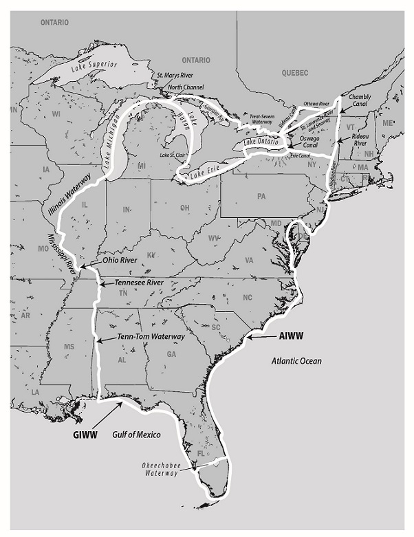
The Great Loop is completed almost entirely in protected waters, with only a few open water passages. These open water passages can easily be crossed in good weather, and thus are enjoyable as well. Starting in Florida, the boater would proceed up the East Coast of the United States on the Atlantic Intracoastal Waterway to Virginia and the Chesapeake Bay. After cruising the Chesapeake and Delaware Bays, the route goes offshore from Cape May to New York harbor. At New York City the route proceeds north up the Hudson River to Troy, NY, then west via the Erie Canal to either Lakes Ontario or Erie. Most "loopers" take the Lake Ontario route which leads to the Trent-Severn Waterway, Georgian Bay and North Channel in Canada. Then it's Lake Michigan to Chicago. Next, the route heads south down the Illinois River to the Mississippi, down the Mississippi to the Ohio and up the Ohio a short 50 miles to the Tennessee River at Paducah, KY. Then, it's south from Paducah, KY via the Tennessee River and the Tennessee-Tombigbee Waterway (usually referred to as the Tenn-Tom) to Mobile Bay and the Gulf Coast.
The cruiser then heads east from Mobile following the protected waters of the Gulf Intracoastal Waterway to Fort Myers, FL. Finally, at Fort Myers the cruiser crosses Florida via the Okeechobee Waterway to Stuart, FL and completes the Great Loop.
Nearly any type of personal watercraft can be used to make this trip. Large and small boats, sailboats, trawlers, motor yacht, houseboats, canoes and jet skis have completed it. You must know your vessel's height and draft requirements.
See this story about the kayaker who completed The Great Loop in 2023.
Your vessel's characteristics will decide, to a certain extent, the route you take. If your vessel draws less than 5 feet and can clear a height of 15', there are no restrictions. You can follow any of several routes. If your vessel draws more than 8 feet or has a height requirement of more than 19'.7", you cannot make the trip. (Chicago is the limiting spot with a fixed bridge of 19' 7".) For sailboats with masts that can be un-stepped or powerboats/trawlers with high structures, some adjustment must be made to the vessels height to get it down to at least 19' and preferably 15'.
In general, height restrictions apply only after you enter the New York Canal System at Troy, NY and continue until you reach Mobile, AL on the Gulf Coast.
It is possible to put the mast of sailboats back up once the vessel has reached the Great Lakes, so the vessel can sail while cruising these waters. However, if you do put the mast back up when you enter the Great Lakes, you will have to un-step it again when you reach Chicago, IL on Lake Michigan. Mast stepping and un-stepping can be performed at marinas just before and after you enter the New York Canal System, Chicago, or Mobile, AL. Information in cruising guides recommended in this book tells you which marinas perform this service.
For vessels sailing north from Florida that draw less than 8 feet and have a height of less than 63 feet there is no need for concern until you reach the New York Canal System at Troy, NY. Before you proceed north of Troy you must get your height down to 20 feet and preferably 15 feet. Once you reach the Waterford, NY you must choose one of 2 basic routes. Via Lake Champlain your height restriction is 17' (Champlain Canal) and depth restriction is 5' (Rideau Canal). The Lake Champlain Route is longer and has more locks and is not recommended as it adds so much to your long trip already. However, if you do not plan to travel the northeast waters again or you are taking more than one year, you may want to squeeze these extra 3 canals into your plan.
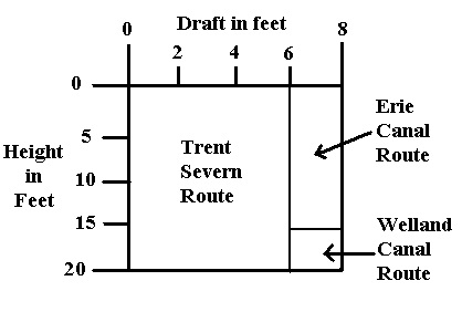
The other choice, and the shorter route, via the Erie Canal, starts with a clearance of 20 feet and the water has a controlled depth of 12 feet. At mile 160 of the Erie Canal, Three Rivers, you must choose between one of three routes based on your height and depth requirements. They are in order of preference:
- Trent-Severn Waterway
- Complete Erie Canal
- Welland Canal
The figure below depicts the height and depth restrictions of the three routes. As you can see, most vessels can transit the Trent-Severn Waterway. Some must go the complete Erie Canal route, but a few each year must go via the Welland Canal.
The Trent-Severn Route
A major part of your decision in choosing the Trent-Severn route is your height and depth requirements. The Trent-Severn has a controlled depth of 6 feet and height of 22 feet. However, if you draw more than 5', you must sign a waiver. The issue with a deep draft is not in the locks, but in the channel and shoaling. For vessels drawing 5' or less there is no problem. From 5 to 6' you must use extra care and get approval to enter the Trent Severn. If you cannot meet these requirements, you must choose one of the two alternatives.
The Trent-Severn Waterway provides the greatest protection, the most to see and do, and most beautiful water to cruise while crossing the Great Lakes. If you can, and do choose this route, you also avoid Lake Erie and Lake Huron while crossing the Great Lakes, thus traveling in more protected waters. The Trent-Severn route starts when you proceed north via the Oswego Canal from Three Rivers on the Erie Canal. You then cross Lake Ontario and enter the Trent-Severn Waterway at Trenton, Ontario in Canada on the northern shore. While crossing the Trent-Severn you will encounter all this historic canal has to offer including, but not limited to, lovely villages, friendly people, the famous "lift locks" and the railway lock. At the west end of the Trent-Severn Waterway you enter Georgian Bay and the area of "30,000 islands". Here you travel in protected waters that are crystal clear providing visibility down 10-12 feet. There are thousands of beautiful quiet anchorages with almost pristine conditions. Georgian Bay and the North Channel, your next destination, provide some of the best cruising waters in North America. Once you cross the North Channel, you enter the top of Lake Michigan and rejoin those boaters who chose or had to go across Lake Erie.
The Complete Erie Canal Route
If you draw more than 6 feet, your first alternative is to go completely across the Erie Canal and enter Lake Erie at Buffalo, NY. However, to proceed west of Three Rivers, mile 160 of the Erie Canal, you must have your clearance down to 15 ½ feet. The western half of the Erie Canal is rich in history and provides many free stops with water and electric. The downside of going the complete Erie Canal route (or the Welland Canal route) is Lake Erie. Over 240 miles long with few natural harbors, Lake Erie can be a burden to cross. When you stop overnight you must go into man-made harbors and often there is no place to anchor. Thus, you are forced to pay to stay in marinas or yacht clubs. Also, because Lake Erie is so large, you can only move in good weather. The prevailing southwest wind will be on the nose. Crossing Lake Erie does not provide anywhere near the interesting stops and beautiful waters that the Trent-Severn Waterway, Georgian Bay and North Channel provide.
The Welland Canal Route
If you can't go the complete Erie Canal or Trent-Severn Routes, then you will have to go through the Welland Canal. Vessels that draw more than 6 feet and have a clearance of between 15 ½ and 19 feet will have to go this way. Following this route you go north from Three Rivers, mile 160 of the Erie Canal, to Oswego on Lake Ontario via the Oswego Canal. Then you transit Lake Ontario, proceeding over 150 miles west. The same restrictions on weather and ports as those on Lake Erie, apply on Lake Ontario. To add insult to injury, when you get to the end of Lake Ontario, you must go up the Welland Canal Locks. These locks are not pleasure craft friendly. It's not that the operators are unfriendly, rather these locks primarily serve Great Lakes freighters and as a result frequent delays are experienced. In addition, because the currents in the locks are so strong you are required to have at least three adult crewmembers on board while transiting the canal going west. If you are short one or two crew members they can be hired at the lock at the Lake Ontario end, to assist you through the locks. You will need 8 to 12 hours to transit the locks and there is no stopping overnight within the Welland Canal. In other words, once committed, you keep going until you reach Lake Erie at the other end.
For more information on the height restrictions and choosing the best route for The Great Loop, purchase a printed Skipper Bob Cruising America's Great Loop or purchase a digital version in the Waterway Guide Mobile App.


- 4,000 Marinas
- Thousands of anchorages
- Updated Charts
- Mile-by-Mile Navigation
- Highlighted Alerts & Cautions
- Full-Color Aerial Photographs

The Waterway Guide App Makes it easy to leave reviews, use our explorer, and view waterway guide materials all on the go!


