The Exumas, a chain of over 350 islands stretching along a northwest and southeast axis for more than 120 nautical miles, embody the quintessential Bahamian cruising experience. From the deserted cays to Great Exuma Island, cruisers can explore a myriad of landscapes protected from ocean swells by natural breakwaters.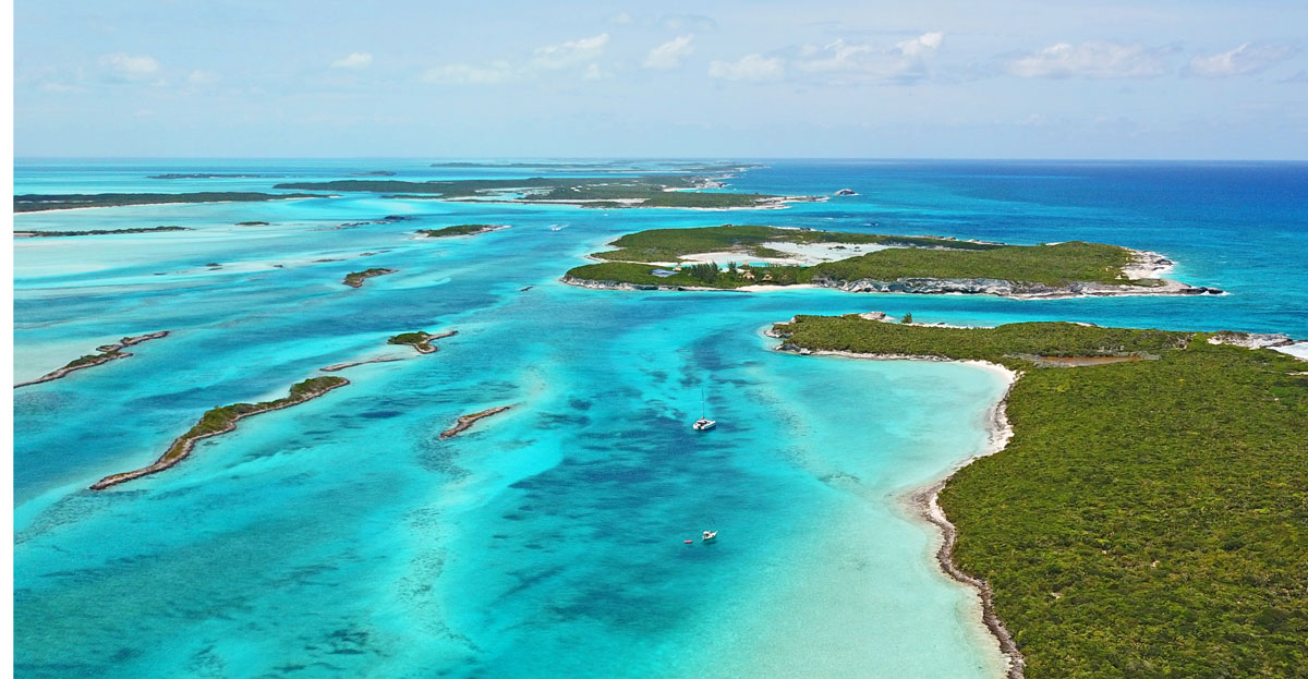
Navigating the Waters
The Exumas invite exploration beyond the beaten path. With protected anchorages on almost every island, cruisers can balance exploration with travel, uncovering new favorites while making steady progress down the chain. The region accommodates both leisurely and quick passages, with the option to navigate in the deep waters of Exuma Sound or along the Great Bahama Bank.
While there are many areas of shallow water, there are work around strategies for most vessels provided crews are adept at reading the water and boat handling in close quarters. When navigating in the Exumas there are routes that can accommodate most drafts, so deeper drafted vessels need not fear missing out.
Regardless of your boating skills or your level of self-sufficiency the Exumas are accessible for all, and it is not uncommon for <30' sailboats to be sharing an anchorage with a 150'+ megayacht.
Prevailing easterly winds in winter and southeasterly breezes in spring favor northbound sailing, suggesting a strategy of powering south to explore more freely with the wind upon return.
Approaching from New Providence
The most common approach to the Exumas begins in New Providence and traverses a portion of the Great Bahama Bank.
Most charts show the paths between the east or west ends of New Providence Island towards the Ship Channel Cay to Highborne Cay blocked by a minefield of coral heads waiting to sink your boat. The reality is that most of the heads are low profile only extending 3-4' above the bottom which means that most vessels of up to 6' draft can pass directly over without issue, even at low tide. It is true that there are a few coral heads in the area larger than others, but they are seen as obvious dark spots and are easily avoided by an alert skipper.
Eleuthera and Cat Island to The Exumas
Traveling across Exuma Sound demands respect for open ocean conditions. Weather and tidal influences on the cuts are crucial considerations for a safe transition from the sound to the tranquility of the Exumas' leeward side.
Anchorage and Dockage
The Exumas boast numerous anchorages and several marinas that cater to a range of needs. It is an area where you can be in an affordable 5-star marina one day and within an hour be in a deserted, pristine anchorage surrounded by white sand beaches.
- Exuma Cays Land & Sea Park Moorings
- Compass Cay Marina
- Staniel Cay Yacht Club
- Farmer's Cay Yacht Club
Have you visited any of these marinas? Leave a review!

Things to Do Around the Exumas
- Warderick Wells - Part of the Exuma Cays Land & Sea Park, this national park is celebrated for its pristine waters, rich marine ecosystem, and opportunities for snorkeling and diving amidst breathtaking scenery.
- Staniel Cay - Between snorkeling, kayaking, and exploring sand bars, the waters surrounding Staniel Cay have much to offer the cruising sailor. After you have completed your fun filled day on the water, enjoy socialization and libations at the Staniel Cay Yacht Club and tour the island by bike or golf cart.
- Black Point - The Black Point settlement on Great Guana Cay has it all–friendly people, great restaurants and a fabulous laundry. We don't usually start with something as mundane as laundry, but Rockside Laundry offers one of the best and most affordable coin-operated washer and dryer facilities in the islands. Ida, who runs the laundry, also serves some of the best conch fritters in the Bahamas.
The Exumas offer a unique cruising experience, blending the beauty of untouched nature with the adventure of exploration. With careful planning and respect for the elements, cruisers can uncover the hidden treasures of this Bahamian paradise, from the shallow bays and deserted cays to the vibrant life beneath the waves.
To learn more about cruising the Exumas plan on using the latest information from Waterway Guide Media
- The Waterway Guide Bahamas 2024 edition and Bahamas Land and Sea mobile app
This combination of a printed book and a digital subscription offers detailed advice and access to insight to hundreds of anchorages and navigation tracks throughout the Bahamas from author Addison Chan and his Land and Sea mobile app that is published on the Waterway Guide mobile platform. Your subscription also includes access to the Waterway Guide book in .pdf version online.
- Explorer Chartbooks from Lewis Offshore, Ltd.
Explorer Chartbooks charts offer details and varied scales in their 12" x 18" water resistant format spiral bound books that contain charts with the latest updates, advice for where to provision, destinations, and more. Cruising, charting, and exploring The Bahamas since 1984, the team at Lewis Offshore, Ltd. publishes the leading three-volume set of chartbooks for the Near Bahamas, Exumas and Ragged Islands, and the Far Bahamas with Turks and Caicos. Electronic data from the Explorer Chartbooks is also available through numerous chart plotter and mobile app providers.
Here is a special bundle price:
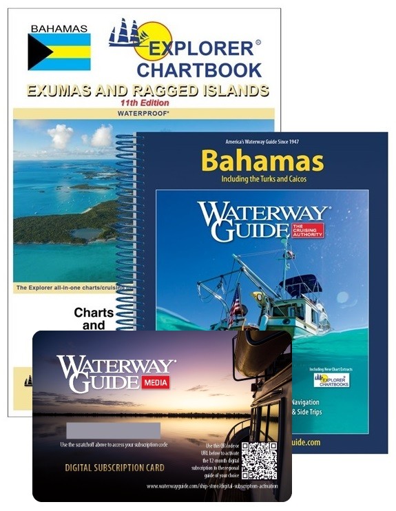
- Aqua Map mobile navigation app for iOS and Android platforms
Aqua Map's mobile app interface displays the Explorer Chartbooks cartography in the same color scheme as the printed charts and maintains the complete downloadable Bahamas chart library in its repository of in-app purchases. Available in both raster and vector formats, the charts in Aqua Map are the same as in the Explorer Chartbooks and Waterway Guide's books. The charts are scalable, searchable, and contain additional data overlays for informed planning and navigation, including Waterway Guide marinas, anchorages, bridges, and fuel locations.
For an overview of the best charts, guidebooks, and apps for your Bahamas adventures, see this article from Waterway Guide Media.
And consider joining the Bahamas Land Sea Facebook group.


- 4,000 Marinas
- Thousands of anchorages
- Updated Charts
- Mile-by-Mile Navigation
- Highlighted Alerts & Cautions
- Full-Color Aerial Photographs

The Waterway Guide App Makes it easy to leave reviews, use our explorer, and view waterway guide materials all on the go!


