Mobjack Bay on the western shore of the Chesapeake Bay offers an escape from bustling marinas and city life. It is where the waters of the East, North, Ware, and Severn Rivers converge over a ten-mile stretch, each adding its unique character to the bay's overall charm. Despite its peaceful demeanor, be mindful of the potential of severe chop when wind and tide are in opposition.
Mobjack Bay's brackish waters are a haven for wildlife; it's not uncommon to see pelicans diving and dolphins chasing mullet into airborne flashes of silver. The remoteness of its creeks, accessible more easily by water than land, guarantees a hush broken only by the natural world. It's quiet and rural surroundings are perfect for cruisers seeking sheltered anchorages who prefer the sound of honking geese over honking cars.
Navigating Mobjack Bay
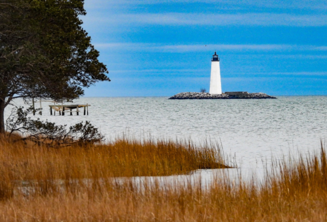
The entrance of Mobjack Bay is marked by a 55-foot high sandstone tower, labeled "ABAND LT HO" on the chart (for abandoned lighthouse). The third oldest lighthouse still standing on the Chesapeake Bay, New Point Comfort Lighthouse was authorized and commissioned by Thomas Jefferson in 1804. Today, though unmanned, the lighthouse marks an area where shoals extend from shore to well beyond the lighthouse and strong currents in this area can produce a nasty chop when flowing against an opposing wind.
Two less visible lights mark the shoal. The 20-foot-high easternmost one is 2.5-second flashing red "2," which looks like an ordinary red ICW marker and can be difficult to spot. The other light is a 15-foot-high, 4-second flashing red "4," which is on a platform to the west. Note the shoal water just north of the two markers and do not drift off course when traveling from one to the other and don't pass too close.
The whole area is a maze of fish traps and crab trap markers. After passing flashing red "4" make sure you spot red daybeacon "6MB" as you turn northwest into Mobjack Bay.
Mobjack Bay's Tributaries
Horn Harbor: A shallow retreat for vessels with drafts under 5 feet, offering a quaint Post Office and local market stocked with basic groceries, fresh seafood, and some marine supplies within biking distance. The 65-slip Hudgins Horn Harbor Marina is a pleasant 2-mile cruise from the entrance and is in a hurricane-safe and tranquil setting. They offer floating covered slips that can accommodate powerboats to 55 feet with full amenities including a saltwater pool. There are many sheltered anchorages in Horn Harbor; just pick a spot based on wind direction.
East River: Famed for its picturesque views and historical lighthouse, the East River boasts straightforward access and cozy anchorages among private homes. Compass Marina is a small (13 slip) marina at the mouth of the East River with floating docks and pump-out service at each slip. They may be able to make room for you in a pinch but do call ahead. The original yard of Zimmerman Marine Inc., respected for its high-quality boatbuilding and restoration work (since 1981), is just across the river from Williams Wharf. Wakes may be troublesome but there are many anchorages along the East River including a deep spot just south of Williams Wharf (in the area of green daybeacon "13").
North River: Both banks of the deep tree-lined North River boast beautiful homes, both old and new, and above Elmington Creek is the private estate of Elmington resembling Thomas Jefferson's Monticello. The friendly Mobjack Bay Marina in Green Mansion Cove off Blackwater Creek can accommodate both powerboats and sailboats up to 50 feet. They offer full maintenance services and allow DIY. Across from the Elmington estate on the upper North River is a nice place to anchor in 6- to 10-foot MLW depths at the mouth of Back Creek.
Ware River: The aptly named "Ware River" may have the greatest number of fish stakes on the Chesapeake, appearing like a picket fence in some spots. (A weir is a set of stakes set to trap fish.) This river is also lined with beautiful estates and home to the private Ware River Yacht Club. You can drop the hook in the shallow cove behind Windmill Point. This spot is well protected from the east and south if you can tuck in close behind. You will find better protection in Wilson Creek, off the south side of the river past Windmill Point.
Severn River: The Severn River is more remote and marshy than the other rivers of Mobjack Bay, particularly at its lower end. The river splits off into the northwest and southwest branches at Stump Point, which are both fairly well marked with good depths. The full-service Severn Yachting Center is is a quiet, wooded location on the northern shore of the Southwest Branch. They offer slips to 120 feet (including 7 reserved transient slips) and first-class amenities including a pool. A popular anchorage is in the northwest branch in a cove in Bryant Bay. The holding is good in mud and you will find little development and few crab trap markers here. You may, however, need bug spray on muggy summer nights.
For more details on navigating Mobjack Bay and surrounding areas, see chapter 23 of Waterway Guide Chesapeake Bay Edition.
Already have a subscription? Click here to read the chapter.


- 4,000 Marinas
- Thousands of anchorages
- Updated Charts
- Mile-by-Mile Navigation
- Highlighted Alerts & Cautions
- Full-Color Aerial Photographs

The Waterway Guide App Makes it easy to leave reviews, use our explorer, and view waterway guide materials all on the go!


