Departing China on 28 March 2024, the eleven boats are to cover 5,306 nautical miles in 37 days before landing on the North American continent for the first time since departing Portsmouth, United Kingdom August 2023.

Washington, D.C is a sponsor of the one of the boats and a host city in June of this year. Waterway Guide Media has collaborated with the city and its networks throughout Chesapeake Bay and U.S. east coast to celebrate the race and its arrival this summer.
To understand one component of the challenges of weather forecasting and navigation faced by skippers and crew, Waterway Guide Media examined what technologies the boats are using. After all, the strategy behind yacht racing has everything to do with plotting a course for the best speed advantage in the conditions encountered. Crews assess weather and sea state conditions and determine how their one-design Clipper 70s will perform to attempt first position at the next checkpoint.
Three sponsors have equipped each Clipper Race yacht with a suite of tools to enhance their safety and performance as they race.
- Timezero TZ Professional weather reporting and routing
- Bookharbour paper charts and guides
- Garmin GPSMAP premium chart plotter with Blue Chart G3 charts
TZ Professional from Timezero uses a routing algorithm that analyzes weather forecasts and the boat's polars (essentially a graph that plots how fast a boat can go given various wind speeds and angles), and performance metrics to determine the safest and fastest route. In other words, TZ Professional helps "do the math" to plot courses that will be the most advantageous. Teams that master the skills of using routing software to navigate the complex and changing conditions of the oceans often find the most success in competitive ocean racing. You may not have or need (or even want) this level of technology for typical cruising.

But in addition to the very best high-tech electronics, Clipper Race crews keep a multitude of paper nautical charts and resources on board provided by race partner Bookharbour. As any savvy cruiser advises, it's always best to have a backup plan if electronics fail. In addition to approximately 130 charts for navigation, the ocean racing yachts are required to carry several official nautical publications to support pilotage in and out of harbors and ports, as well as enable celestial navigation calculations. They receive regular Notices to Mariners and can keep their library updated via Bookharbour.
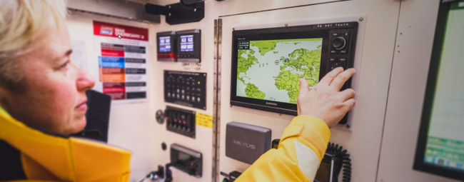
The third supplier, multinational tech brand Garmin, has been a Clipper Race sponsor for the last decade. With their premium chart plotters and most advanced nautical charts on board, Garmin can showcase and get feedback from seasoned race crews as they navigate around the globe.
Science, good judgment, and a bit of luck will determine who wins the individual races. And with 8 legs, 6 ocean crossings, over 700 crew participants within twelve months , and 40,000 nautical miles of sailing, there are multiples opportunities for victory at many levels.
Waterway Guide Media and Events DC are pleased to participate in this global challenge and look forward to hosting the Clipper Round the World Race in June 2024 in the nation's capital at The Wharf on the Potomac River.
Sources
Clipper Boats Navigation tools
2023-2024 Partners and Suppliers
Important Links
Ports of Call to Date and Final Leg and Map
Follow the Race boats with the Race Viewer
Take a Tour of a Boat (virtual)
https://www.sailmagazine.com/racing/racing-into-the-wild
Prior Coverage


- 4,000 Marinas
- Thousands of anchorages
- Updated Charts
- Mile-by-Mile Navigation
- Highlighted Alerts & Cautions
- Full-Color Aerial Photographs

The Waterway Guide App Makes it easy to leave reviews, use our explorer, and view waterway guide materials all on the go!


